Software
Ubudu has developed a full suite of applications to manage and integrate Ubudu RTLS as well as make use of end-user applications to provide operational value right away.
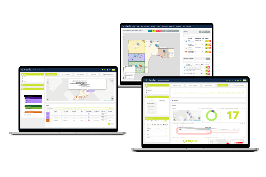
Software Applications
Configure, manage and supervise the entire system, get operational value from end-user applications available off-the-shelf and integrate data to your systems through Ubudu SDKs and APIs.
Monitor and configure your RTLS solution with Location Engine.
Search for your assets positions and trajectories with the RTLS Application.
Create and manage your different maps/sites with the Map Manager.
Remote bi-directional communication with all your BLE devices on site.
Location Engine
Location engine is the application used for the configuration, testing, management and supervision of RTLS.
The same Location Engine account can be used to compute positions on the same map with different technologies simultaneously.

Manage anchors placement through drag-and-drop, check their status and battery level.
Monitor anchors activity
The status of the anchors is shown directly on the map using a colour code.
Anchors placement
Drag-and-drop your anchors to place them correctly on the map
Remote battery management
Check the real-time battery levels of your wireless anchors

Configure the anchors and apply it to the devices directly from your desk.
Configure easily all your anchors over the air
Verify and modify the anchor configuration without having to physically connect to the gateway on-site.
Hybrid configuration
The Ubudu Hybrid Anchors V2 can be configured to scan both BLE and UWB signals simultaneously.
Adjust the height
Input the exact height at which each anchor is installed to ensure best accuracy.
.png)
This view shows real time tags positions computed and enables you to see which anchor is receiving signal from which tag for fine-tuning.
Real time view
See the real-time position of the tags on the map.
Position computation details
Quickly identify which anchors are used for position computation.
Fine-tuning
See which anchor is receiving signal from which tag to fine-tune the set-up and get the best results

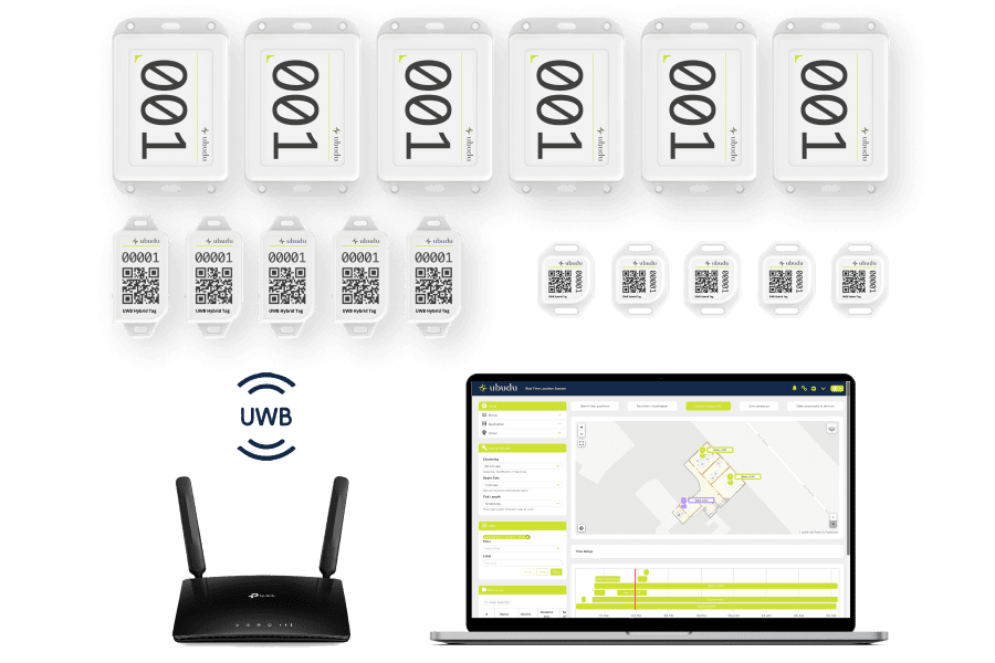
Quick, reliable and exhaustive hardware import, through an automatic detection of all tags, anchors and wireless anchors visible in your network.
Automatic import
Import easily all your active devices via a cvs file, with a zero error guarantee.
Battery level visibility
See the real-time battery level of all your tags
Manage tags list
Import, export, activate, deactivate and delete tags easily.

A simplified and an advanced mode in order to configure the computation engine algorithms to match your requirements.
Precise settings for each algorithm
Fine-tune the algorithm using the right settings in order to adapt the solution to all environments.
Multiple computation algorithms
Different algorithms are available to be used simultaneously in order to compute positions using different technologies
Gateway bridging
Bridge all gateways to a new server at the same time.
.png)
With Map matching, improve localisation accuracy by fixing positions on predefined paths.
Position fix on paths
Guarantee position on the paths taken by the assets to reduce inaccuracies.
Better flow analysis
Less positioning error therefore more representative analytics.
No position jump
Have an accurate representation of the path taken by assets.
Easy configuration
Simply draw the paths on the floor plan using Ubudu web app.
RTLS Application
Ubudu RTLS Application is an end-user application used by operators to search for the location of an asset, receive real-time alerts and analyse the operational flows.
Quickly find the location of your assets using filter or simply searching by asset name or ID.
Show only assets belonging to the same family
Select a family of asset to see only these assets on the map. Each family of asset can have a different colour for easier identification.
Search by asset name/ID or with filters
Search for a specific asset by typing its name or ID in the search bar or filter assets by zone or by type.
Get asset information
Simply click on the asset on the map to see all asset information including asset type, name, ID etc...

View assets real-time positions on the map and receive real-time alerts based on the rules configured.
View real-time positions on the map
All assets' positions are shown on the map and details about assets present in different zones are reported in a table.
Real-time geofencing alerts
Email alerts or pop-up notifications can be set when a tag spends too much time in a zone or enters/exits a specific zone for exemple.
Real-time counter per zone
Quickly see how many tags are present in each zone using the real-time counters per zone on the map.

Configure any type of geofence or alert in "No-Code" through this easy-to-use interface.
Simple alerts personalisation
Customise alert configurations according to your specific needs. With this feature, you can set multiple conditions based on asset movements and specific attributes that it has such as asset type, maintenance date, work order number etc...
Different types of actions can be taken
Once the rule conditions are met, different types of actions can be taken: receive a personalised email, generate a pop-up on your screen and/or send an HTTP POST request to any system.
Test the configured rules before implementation
Simulate the alert rules configured to identify any potential issues or errors in your alert configurations and make any necessary adjustments before implementing it into the system.

All historical positions data are stored and the trajectories on a specific time range can be replayed on the map.
Analyse asset movement during a specific time range
Select a time range in the application and replay the trajectories of the equipments selected.
Search for the position of an asset at a specific date and time
Select a specific date and time to have a screenshot of all your assets positions at that specific date and time.
Replay all trajectories or focus on specifics assets
Replay all asset trajectories or focus on a specific asset by using the different filters.

Create your own personalised dashboard to analyse your operational flow, understand equipment utilisation rates and have an automatic localised inventory of your assets.
Analyse operational flow
Visualise how assets are moving between zones using a flow diagram, how much time they spend in each zone using a pie chart or see where most positions are calculated through the heatmap.
Understand equipment utilisation rates
Quickly identify how equipment are being used by analysing how long they spend in different zones and how often they move from one zone to another.
Automatic localised inventory
See how many assets you have per category and where they are located automatically.

Associate additional custom information about your assets to the Ubudu Tags in order to classify them by attribute for the search and analytics features.
Associate any asset attribute to your tags
Create as many attributes as you need, name them as you want and use the right data format for each of your attribute associated to your tags : string, number, boolean, array, date or time.
Customise alerts based on your attributes
By associating custom attributes with your tags, you can generate alerts not only based on location or movement but also on the asset attributes you created.
Analyse data more easily
By tailoring the attributes to your company's own classification, the user will be able to understand better the data generated by the system in order to make informed business decisions.

Map Manager
Manage your site's map, zones and beacon placement with Ubudu Map Manager.
Manage your beacon infrastructure easily by placing beacons on the map using drag-and-drop
Import beacons batch easily
Export beacons batch from the Ubudu MapTool application and import it on the Map Manager
Beacons placement
Drag-and-drop your beacons to place them correctly on the map
.png)
Create, name, modify the shape and delete zones directly on your map.
Manage zones
Create zones, draw them on the map and give them a name to be able to locate tags by zone and create geofences.
Group zones by keywords
Add keywords to the zones to create filters by group of zones in the Analytics Dashboard on RTLS Application.

Upload your map file and georeference it in order for the system to be able to compute positions in lat. long. format.
Geographic coordinates
Georeferencing your map enables you to compute assets geographic coordinates in lat. long. format.
Site's map integrated in a global map
Georeferencing the site's map allows you to integrate it in a global map/view and ensure the size of the map is correct.
BLE Controller
Communicate remotely with BLE devices deployed on-site through Ubudu Hybrid Anchors for Pick-to-light, On-Demand localisation and OTA (Over-The-Air) configuration.
Pick-to-Light
Activate the LED on the tag to find the asset your are looking for more quickly.
On-Demand Localisation
Request localisation of your tag(s) when you need it to reduce battery consumption and perform timely and localised inventories.
OTA Configuration
Remotely configure any BLE device without having to go on-site. Multiple devices can be configured simultaneously.

Our System Integrator Partners


Software Integrations
Ubudu RTLS Application comes with an open API to integrate RTLS data directly into client systems. Ubudu can also fetch data from client systems if they provide API to display asset data in the RTLS Application from a CMMS or ERP for example.
CMMS
ERP
MES
WMS
Plug-and-play Starter Kits including Ubudu hardware, software, tools and documentation in order to let you test and show demos of Ubudu RTLS in no time.
Ubudu RTLS: The Ultimate Tracking Solution for Different Industries
Ubudu solutions are tailored to meet diverse needs across a range of industries. From optimising operations and enhancing visitor experiences to improving asset traceability and worker safety, our versatile solutions provide efficient and effective results.
RTLS for Manufacturing & Logistics
Make your operations more efficient by optimising operational flows and increasing visibility on production.
RTLS for Quick Service Restaurant
Avoid time wasted by waiters searching for customers at their table and make your customer experience more seamless.
RTLS for
Healthcare
Make it easy for your staff to find equipment they need, reduce yearly expenditure on new equipment and improve patient satisfaction.
RTLS for Construction
Optimise the usage of expensive machinery on-site and reduce the risk of accidents caused by collisions or hazardous zones.
Yes it is possible to host the Ubudu RTLS software on-premise and we can provide supervision tools for your IT to maintain the system easily.
Cloud subscription is also possible through our SaaS model which includes software hosting, maintenance, support and evolutions.
Our end-user application interface supports today French, English, simplified Chinese and traditional Chinese. More languages can be added on-demand.
Yes, Ubudu Access Control Server (ACS) gives granular control over access permissions and access to data in RTLS Application.
Yes it is possible, the Ubudu Location Engine can be used to compute simultaneously on the same map the positions of both UWB and BLE tags. You can also make use of Ubudu Hybrid Anchors v2 in order to have the same infrastructure to compute positions of both UWB and BLE tags.