Software
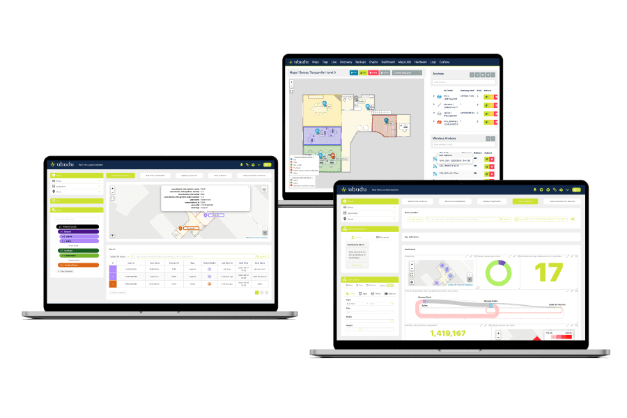
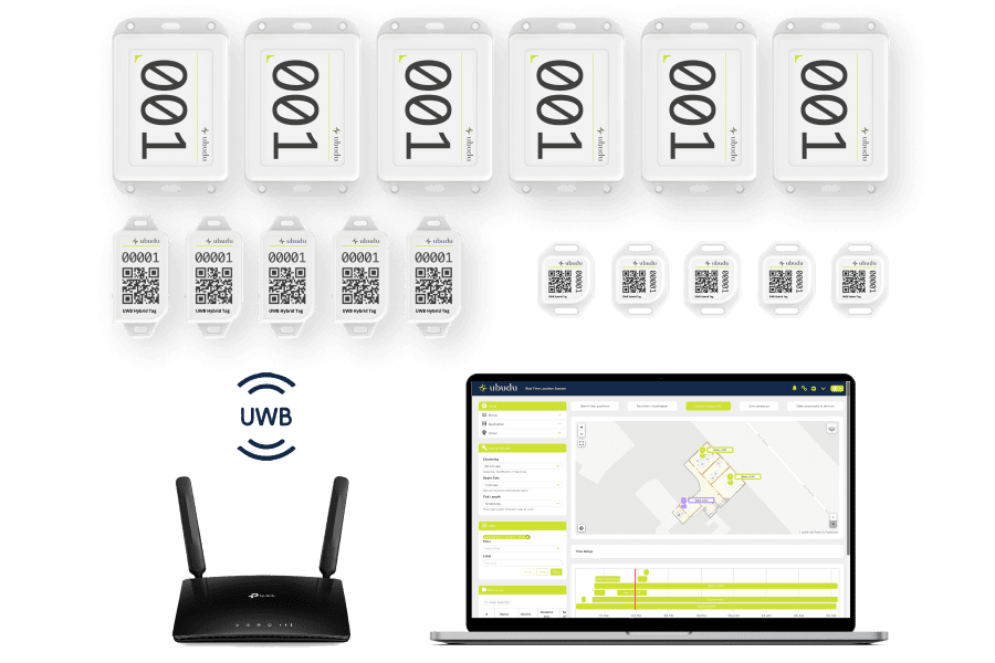
Ubudu hat ein komplettes Paket von Anwendungen entwickelt, um Ubudu RTLS zu verwalten und zu integrieren sowie Endbenutzeranwendungen zu nutzen, um sofort einen betrieblichen Nutzen zu erzielen.

Software-Anwendungen
Konfigurieren, verwalten und überwachen Sie das gesamte System, nutzen Sie den operativen Wert von standardmäßig verfügbaren Endbenutzeranwendungen und integrieren Sie Daten in Ihre Systeme über Ubudu SDKs und APIs.
Überwachen und konfigurieren Sie Ihre RTLS-Lösung mit Location Engine.
Suchen Sie mit der RTLS-Anwendung nach den Positionen und Flugbahnen Ihrer Objekte.
Erstellen und verwalten Sie Ihre verschiedenen Maps/Sites mit dem Map Manager.
Bidirektionale Fernkommunikation mit all Ihren BLE-Geräten vor Ort.
Standort Motor
Location Engine ist die Anwendung, die für die Konfiguration, Prüfung, Verwaltung und Überwachung von RTLS verwendet wird.
Ein und dasselbe Location Engine-Konto kann zur gleichzeitigen Berechnung von Positionen auf derselben Karte mit verschiedenen Technologien verwendet werden.
Verwalten Sie die Platzierung von Ankern per Drag-and-Drop, überprüfen Sie ihren Status und den Batteriestand.
Konfigurieren Sie die Verankerungen und wenden Sie sie direkt von Ihrem Schreibtisch aus auf die Geräte an.
In dieser Ansicht werden die berechneten Positionen der Tags in Echtzeit angezeigt, und Sie können sehen, welcher Anker von welchem tag ein Signal empfängt, um eine Feinabstimmung vorzunehmen.
Schneller, zuverlässiger und umfassender Hardware-Import durch automatische Erkennung aller in Ihrem Netzwerk sichtbaren Tags, Anker und Funkanker.
Ein vereinfachter und ein erweiterter Modus, um die Algorithmen der Berechnungsmaschine Ihren Anforderungen entsprechend zu konfigurieren.
Mit Map matching verbessern Sie die Lokalisierungsgenauigkeit, indem Sie Positionen auf vordefinierten Pfaden festlegen.
RTLS-Anwendung
Die Ubudu RTLS-Anwendung ist eine Endbenutzeranwendung, die von den Betreibern verwendet wird, um den Standort einer Anlage zu suchen, Echtzeitwarnungen zu erhalten und die Betriebsabläufe zu analysieren.
Finden Sie schnell den Standort Ihrer Assets, indem Sie Filter verwenden oder einfach nach Asset-Name oder ID suchen.
Zeigen Sie die Echtzeit-Positionen von Assets auf der Karte an und erhalten Sie Echtzeit-Warnungen auf der Grundlage der konfigurierten Regeln.
Konfigurieren Sie jede Art von Geofence oder Alarm in "No-Code" über diese einfach zu bedienende Schnittstelle.
Alle historischen Positionsdaten werden gespeichert und die Trajektorien eines bestimmten Zeitraums können auf der Karte wiedergegeben werden.
Erstellen Sie Ihr eigenes personalisiertes Dashboard, um Ihren Betriebsablauf zu analysieren, die Auslastung der Geräte zu verstehen und eine automatische, lokalisierte Bestandsaufnahme Ihrer Anlagen zu erhalten.
Verknüpfen Sie zusätzliche benutzerdefinierte Informationen über Ihre Assets mit den Ubudu Tags, um sie für die Such- und Analysefunktionen nach Attributen zu klassifizieren.
Kartenmanager
Verwalten Sie die Karte Ihrer Website, die Zonen und die Platzierung der Baken mit dem Ubudu Map Manager.
Verwalten Sie Ihre Beacon-Infrastruktur ganz einfach, indem Sie Beacons per Drag-and-Drop auf der Karte platzieren.
Laden Sie Ihre Kartendatei hoch und geben Sie eine Georeferenz ein, damit das System die Positionen im Längen- und Breitenformat berechnen kann.
BLE Controller
Kommunizieren Sie aus der Ferne mit BLE-Geräten, die vor Ort über Ubudu Hybrid Anchors für Pick-to-light, On-Demand-Lokalisierung und OTA (Over-The-Air) Konfiguration eingesetzt werden.
Unsere Systemintegrator-Partner


Software-Integrationen
Die Ubudu RTLS-Anwendung verfügt über eine offene API, um RTLS-Daten direkt in Client-Systeme zu integrieren. Ubudu kann auch Daten von Client-Systemen abrufen, wenn diese eine API bereitstellen, um Anlagendaten in der RTLS-Anwendung anzuzeigen, zum Beispiel von einem CMMS oder ERP.
CMMS
ERP
MES
WMS

Plug-and-Play-Starter-Kits mit Ubudu-Hardware, Software, Tools und Dokumentation, damit Sie Ubudu RTLS im Handumdrehen testen und vorführen können.

Ubudu RTLS: Die ultimative Tracking-Lösung für verschiedene Branchen
Die Lösungen von Ubudu sind auf die unterschiedlichsten Bedürfnisse in einer Reihe von Branchen zugeschnitten. Von der Optimierung von Abläufen und der Verbesserung des Besuchererlebnisses bis hin zur Verbesserung der Rückverfolgbarkeit von Vermögenswerten und der Sicherheit der Mitarbeiter - unsere vielseitigen Lösungen liefern effiziente und effektive Ergebnisse.
RTLS für Fertigung und Logistik
Erhöhen Sie die Effizienz Ihrer Abläufe, indem Sie die Betriebsabläufe optimieren und die Transparenz der Produktion verbessern.
RTLS für Schnellrestaurants
Vermeiden Sie Zeitverluste durch die Suche von Kellnern nach Kunden an deren Tischen und sorgen Sie für einen reibungslosen Kundenkontakt.
RTLS für
Gesundheitswesen
Erleichtern Sie Ihren Mitarbeitern das Auffinden der benötigten Geräte, reduzieren Sie die jährlichen Ausgaben für neue Geräte und verbessern Sie die Patientenzufriedenheit.
RTLS für das Bauwesen
Optimieren Sie den Einsatz teurer Maschinen vor Ort und reduzieren Sie das Unfallrisiko durch Kollisionen oder Gefahrenzonen.
Ja, es ist möglich, die Ubudu RTLS-Software vor Ort zu hosten und wir können Überwachungswerkzeuge für Ihre IT bereitstellen, um das System einfach zu warten.
Ein Cloud-Abonnement ist auch über unser SaaS-Modell möglich, das Software-Hosting, Wartung, Support und Entwicklungen umfasst.
Unsere Endbenutzer-Anwendungsschnittstelle unterstützt heute Französisch, Englisch, vereinfachtes Chinesisch und traditionelles Chinesisch. Weitere Sprachen können bei Bedarf hinzugefügt werden.
Ja, Ubudu Access Control Server (ACS) ermöglicht eine granulare Kontrolle über die Zugriffsberechtigungen und den Zugriff auf Daten in der RTLS-Anwendung.
Ja, es ist möglich, die Ubudu Location Engine kann verwendet werden, um gleichzeitig die Positionen von UWB- und BLE-Tags auf derselben Karte zu berechnen. Sie können auch Ubudu Hybrid Anchors v2 verwenden, um die gleiche Infrastruktur zur Berechnung der Positionen von UWB- und BLE-Tags zu nutzen.


.png)


.png)


.png)


